East Antarctic heat transport
Observational and satellite-based studies of how warm water is transported from offshore basins to the continental shelf and ice-shelf fronts.
I study ocean circulation, heat transport, and ice–ocean–sea ice interactions in polar oceans, with a particular focus on East Antarctica. My research combines satellite remote sensing, ship-based observations, mooring observations, and data analysis to understand how ocean heat reaches Antarctic continental shelves and ice-shelf cavities.
My research addresses how relatively warm offshore waters are transported toward the Antarctic continental shelf and eventually into ice-shelf cavities. Around the Totten and Cook ice-shelf sectors in East Antarctica, this oceanic heat transport is a key process linking offshore ocean circulation, coastal dynamics, and ice-sheet change.
A major focus is the role of mesoscale eddies, the Antarctic Slope Current and Antarctic Slope Undercurrent, coastal gyres, shelf-break topography, and large-scale atmospheric variability such as the Southern Annular Mode. I use satellite-derived sea level and dynamic ocean topography together with hydrographic and velocity observations to diagnose these processes.
Observational and satellite-based studies of how warm water is transported from offshore basins to the continental shelf and ice-shelf fronts.
Development and application of satellite-altimeter-based dynamic ocean topography fields to infer polar ocean circulation, including sea-ice-covered regions.
Analysis of how atmospheric variability, coastal sea level, gyres, eddies, and shelf-slope currents modulate poleward heat transport.
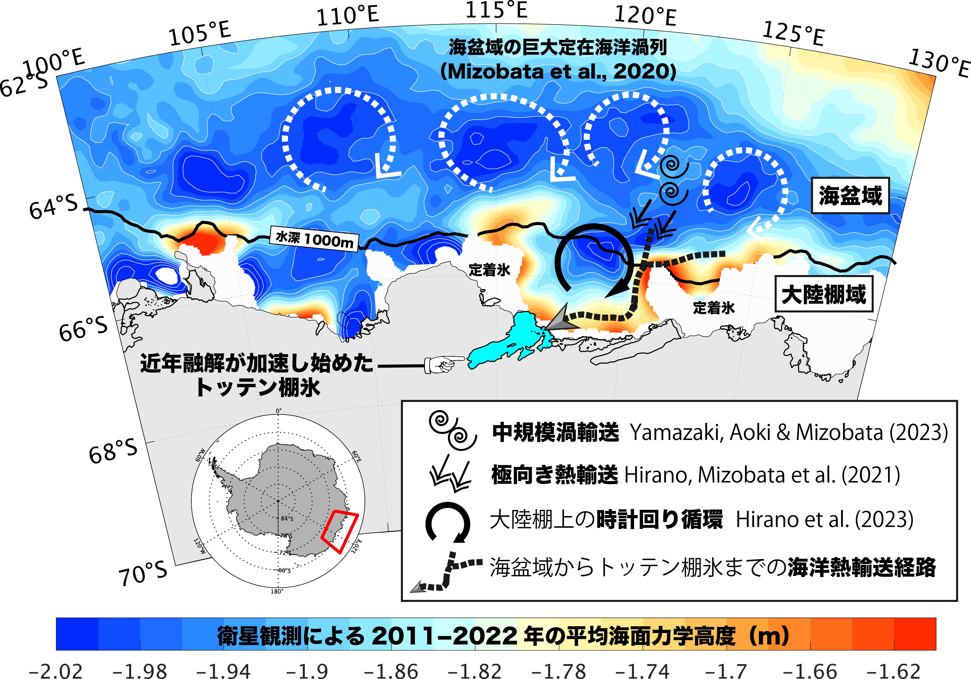
Ocean circulation transports warm water from offshore basins to the continental shelf and into ice-shelf cavities, where ocean heat can control basal melting.
Research datasets distributed by Kohei Mizobata are available from the data-sharing page. The datasets include upper-ocean XCTD profiles used for reproducibility of Antarctic coastal marine heatwave analysis and ADS-registered monthly dynamic ocean topography datasets derived from satellite radar altimeters.
XCTD profile subset used in the Antarctic coastal marine heatwave study, limited to the upper 0–150 m / dbar and grouped by collocated GHRSST MUR SST anomaly terciles.
Download MAT fileMonthly gridded dynamic ocean topography datasets for the Arctic Ocean and Southern Ocean derived from satellite radar altimeter measurements.
Open data-sharing pagePlease see the following external profiles for publications, research projects, and researcher identifiers.