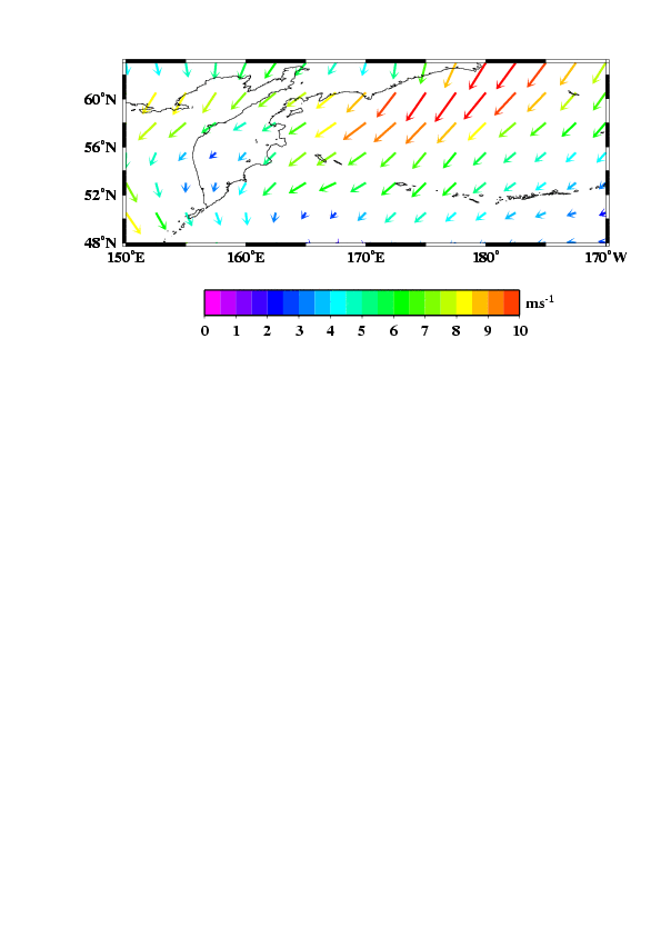
以下の例ではNECP/NCAR再解析データセットからある年の1月の風速データを作成し、マッピングしている。
grdvectorはsurface(もしくはxyz2grd)で作成したグリッドファイル(netcdf形式)を読む。
grdvector U方向の速度のグリッドファイル V方向の速度のグリッドファイル -Jx・・・・・・
となっていることに注意。
wndv.txt
##########################
gmtset ANOT_FONT 5 TICK_LENGTH 0.1 ANOT_FONT_SIZE 14
gmtset BASEMAP_TYPE fancy FRAME_WIDTH 0.1c GRID_PEN 5 GRID_CROSS_SIZE 0.3
gmtset DEGREE_FORMAT 3 COLOR_FOREGROUND 255/0/0
gmtset VECTOR_SHAPE 1.0
set ofile=windvect.ps
echo $ofile
set latmin=48
set latmax=63
set lonmin=150
set lonmax=190
set rr=$lonmin/$lonmax/$latmin/$latmax # mapping range
echo "study area="$rr
set jj=0.15id # -Jm option parameter
set iopt=2.5
#arrowwidth/headlength/headwidth [Default is 0.03i/0.12i/0.09i]
set qopt=0.03i/0.1i/0.06i #qopt=0.04i/0.05i/0.05i JAPAN
set bopt=10f5/4f2WeSn
set sopt=10 # 20m for 1cm
#------------------------------------
set windu=wndu.grd
set windv=wndv.grd
makecpt -Crainbow -T0/10/0.5 >! ncep.cpt
surface wndu.txt -G$windu -R$rr -I$iopt # ここでu方向のグリッドファイルを作成
surface wndv.txt -G$windv -R$rr -I$iopt # ここでv方向のグリッドファイルを作成
grdvector $windu $windv -Jx$jj -R$rr -B$bopt -Q$qopt -Cncep.cpt -S$sopt -I$iopt -K -P -X4 -Y22 >! $ofile
pscoast -R$rr -Jx -Dh -B -W2/0/0/0 -O -K >> $ofile
psscale -Cncep.cpt -D3.5/2.5/10.0/0.8h -B1::/:ms@+-1@+: -O -X4 -Y-4 >> $ofile
exit